In this VFR - GPS Flight Plan we take off from the airport of Wau (HSWW) [South Sudan], fly southwards to overfly the Southern National Park and then to the southeast towards Juba, where we will land in its airport (HSSJ) [South Sudan].
At the bottom of this page you will find the download link of this Flight Plan (.PLN file)

In this VFR - GPS Flight Plan we take off from
the airport of Wau (HSWW) [South Sudan], fly southwards to overfly the Southern
National Park and then to the southeast towards Juba, where we will land in its
airport (HSSJ) [South Sudan].
Find below a short extract and screenshots of the main points of the route. In this journey around Africa I have used the Cessna 172S (Skyhawk)

Take off from the dirt runway 09 of the airport of Wau, right before turning to
the south.
Wau Airport is a civilian airport that serves the city of Wau and surrounding communities. Feeder Airlines has three return flights a week between Khartoum-Wau-Juba. Southern Star Airlines used to provide service on Wednesdays and Sundays to Juba; however, this service has been suspended in 2011 when the airline ceased flying.
Wau Airport (IATA: WUU, ICAO: HSWW) is located in Wau County, Wau State, in the city of Wau. The airport is located to the northeast of the central business district of the city.
This location lies approximately 511 kilometres (318 mi), by air, northwest of Juba International Airport, the largest airport in South Sudan. The geographic coordinates of Wau Airport are: 7° 72' 58.12"N, 27° 97' 31.00"E (Latitude: 7.7250; Longitude: 27.9800). This airport sits at an elevation of 433 metres (1,421 ft) above sea level. In December 2012. a new paved runway measuring 2,500 metres (8,200 ft) in length was opened. (*1) [NR: FS2020 does not show that new paved runway]

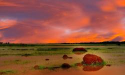
Leaving Wau and the Jur River.
The Jur River (also Sue River) is a river in western South Sudan, flowing through the Bahr el Ghazal and Equatoria regions. About 485 kilometres (301 mi) long, it flows north and northeast, joining the Bahr el Ghazal River on the western side of the Sudd wetlands. The Jur River (Luo River) is part of the Nile basin, as the Bahr al-Ghazal flows into the White Nile.
The Luo River is a seasonal stream. Its discharge can reach 400 m3/s (14,300 cu ft/s) in September.
The upper course of the Luo River is also called the Sue. (*1)
 |
||
| Wetlands of the
Jur River in Wau State By Michael Walsh - CC BY 3.0 |

Flying to the south near the Sue River, than is the name of the Jur (or Luo)
River in its upper course.

Overflying the Southern National Park.
The Southern National Park is a national park in South Sudan. It was established in 1939. This site has an area of 23,000 km2.
A.B. Anderson, a former Assistant Game Warden, reported that in 1950 that the Southern National Park was spread over an area of 7,800 square miles (20,000 km2). It was drained by three rivers: the Sue River to the west, a well-defined channel that joined the Nile; the Gel River to the east; and the Ibba River in the centre of the park. The Gel and Ibba Rivers, after flowing through the park, formed a flood plain which made the habitat swampy.
Bushveld, true rainforest vegetation, forests in laterite soils and gallery forests were found in the park. During the monsoon season, the park had extensive grassland that grew up to about 15 feet (4.6 m). The soil was generally of whitish clay and there were sandy valleys. The park was thinly populated and visited by very few tourists. Hunting, fishing and honey collection were the common vocations of the people living in the park area.
He identified aquafauna in the rivers flowing through the park as aba, an eel-like fish, tilapia, Nile bichir, lung fish, catfish, and a few crocodiles. Mammals reported to have been present in the park during Anderson's time in Southern Sudan were giant eland, waterbuck, kob, hartebeest, korrigum, African buffalo, Kordofan giraffe, oribi, northern white rhino, reedbuck, lion, colobus monkey, various galagos including the Senegal bushbaby, and giant forest hog. Anderson also reported that marabou storks and pelicans were present in some regions of the park. (*1)

Terrain becomes greener as we fly to the southeast.

A narrow river (Tonj/Ibba river?)

Overflying the Gel River

Stormy weather once again.

Approaching Juba at sunset we can see the White Nile again, after quite a few
days.

Final approach to runway 13 of the airport of Juba, with the While Nile
behind it.
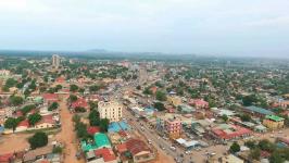
Juba is the capital and largest city of South Sudan. The city is situated on the White Nile and also serves as the capital of the Central Equatoria State. It is the world's newest capital city, and had a population of 525,953 in 2017. It has an area of 52 km2 (20 sq mi), with the metropolitan area covering 336 km2 (130 sq mi).
Juba was established in 1920–21 by the Church Missionary Society (CMS) in a small Bari village, also called Juba. The city was made as the capital of Mongalla Province in the late 1920s. The growth of the town accelerated following the signing of the Comprehensive Peace Agreement in 2005, which made Juba the capital of the Autonomous Government of Southern Sudan. Juba became the capital of South Sudan in 2011, but influential parties wanted Ramciel to be the capital. The government announced the move of the capital to Ramciel, but is yet to occur.
Juba has been described as undergoing an economic boom, especially in the past five years and since independence. The prospect of an economic boom has brought thousands of merchants to Juba, mostly from northern Sudan and from East Africa. As of October 2010, several regional and international businesses have established a presence in Juba. The Commercial Bank of Ethiopia and the Kenyan banking conglomerate Kenya Commercial Bank has its South Sudanese headquarters in the city and a branch network of eleven (11) branches throughout South Sudan. The three indigenous South Sudanese commercial banks namely; Buffalo Commercial Bank, Ivory Bank and Nile Commercial Bank, all maintain their headquarters in Juba. Equity Bank, another regional finance services provider also has a branch in Juba. National Insurance Corporation (NIC), the leading Ugandan insurance services provider, maintains an office in the city. Despite recent economic difficulties brought about by the December 15th 2013 civil war, Juba has continued to grow and construction is still booming. This is probably due to the high demand for affordable housing and hotel accommodations. Research from the Overseas Development Institute found that markets in Juba are transient, as many traders only come to make a quick profit and so do not invest in storage facilities or shops. (*1)
 |
 |
 |
| View of Juba By D Chol - CC BY-SA 4.0 |
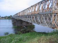
Juba Bridge, a Bailey bridge over
the White Nile By DEMOSH - CC BY 2.0 |
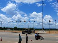
John Garang
Mausoleum Square in Juba By Jens Klinzing - CC BY-SA 3.0 |
You can download for free this Flight Plan but only for your own private use. It is strictly forbidden to share it or publish it in other sites, forums, newsgroups or in any other way . You are encouraged to share and publish links to this page only, but not direct links to the file itself.
(*1) Credits: The descriptive texts are mainly an excerpt of those provided by Wikipedia. Visit Wikipedia to read the full descriptions.
See other MS Flight Simulator flight plans and instructions
Disclaimer: These instructions and flight plan are intended to be used only for MS Flight Simulator and should not be used for real flights.