
In this VFR - GPS Flight Plan we take off from the airport of Port Sudan (HSPN) [Sudan], fly to the southeast near the coast of the Red Sea and above the mountains, and finally land in the airport of Massawa (HHMS) [Eritrea].
At the bottom of this page you will find the download link of this Flight Plan (.PLN file)

In this VFR - GPS Flight Plan we take off from
the airport of Port Sudan (HSPN) [Sudan], fly to the southeast near the coast of
the Red Sea and above the mountains, and finally land in the airport of Massawa
(HHMS) [Eritrea].
Find below a short extract and screenshots of the main points of the route. In this journey around Africa I have used the Cessna 172S (Skyhawk)

After taking off from the airport of Port Sudan we fly to the southeast
following the coast of the Red Sea.
Port Sudan New International Airport (IATA: PZU, ICAO: HSPN) is an airport serving Port Sudan, Sudan. Located 20 kilometers south of the city, PZU is the second largest international airport in Sudan in terms of air traffic and international destinations served. Port Sudan New International Airport is a full member of the IATA as of 2014. (*1)

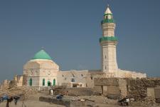
Overflying Suakin.
Suakin or Sawakin (Arabic: سواكن, romanized: Sawákin, Beja: Oosook) is a port city in northeastern Sudan, on the west coast of the Red Sea. It was formerly the region's chief port, but is now secondary to Port Sudan, about 50 kilometres (30 mi) north.
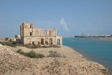
Suakin used to be considered the height of medieval luxury on the Red Sea, but the old city built of coral is now in ruins. In 1983 it had a population of 18,030 and the 2009 estimate is 43,337. Ferries run daily from Suakin to Jeddah in Saudi Arabia.
The Beja name for Suakin is Oosook. This is possibly from the Arabic word suq, meaning market. In Beja, the locative case for this is isukib, whence Suakin might have derived. The spelling on Admiralty charts in the late 19th century was "Sauakin" but in the popular press "Suakim" was predominant. (*1)
 |
 |
|
|
Suakin, El-Geyf mosque By Bertramz - CC BY 3.0 |
Suakin,
ruins of egypt national bank By Bertramz - CC BY 3.0 |

Getting closer to the mountain chain between Sudan and Eritrea.

Mountains above 4,000 feet high.

Entering Eritrea.

The highest point of our route, with mountains above 8,000 feet.

Leaving the mountains behind we started to descend.

Approach to the airport of Massawa, just before the final ILS approach to
runway 07.
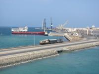
Massawa (/məsˈɑːwə/ muh-SAH-wuh is a port city in the Northern Red Sea region of Eritrea, located on the Red Sea at the northern end of the Gulf of Zula beside the Dahlak Archipelago. It has represented a historically important port for many centuries. It was the capital of the Italian Colony of Eritrea until the seat of the colonial government was moved to Asmara in 1897.
Massawa has an average temperature of 30°C / 86°F, which is one of the highest found in the world, and is "one of the hottest marine coastal areas in the world.
Massawa was originally a small seaside village, lying in lands coextensive with the Kingdom of Axum—also known as Kingdom of Zula in antiquity—and overshadowed by the nearby port of Adulis about 50 kilometres (31 mi) to the south. Massawa has been ruled or occupied by a succession of polities during its history, including the Aksumite Empire, Abyssinia and Italian Eritrea. Following the fall of Axum in the 8th century, the area around Massawa and the town itself fell under the occupation of the Umayyad Caliphate from 702 to 750 CE. The Beja people would also come to rule within Massawa during the Bajag Kingdom of Eritrea from the year 740 to the 14th century. Massawa was situated between the sultanates of Qata, Baqulin, and Dahlak. Midri-Bahri, an Eritrean kingdom (14th–19th centuries), gained leverage at various times and ruled over Massawa. The port city would also come under control of the Balaw people during the Balaw Kingdom of Eritrea (12th–15th centuries). At this time, the Sheikh Hanafi Mosque, one of the country's oldest mosques, was built on Massawa Island. The city reportedly has the oldest mosque in Africa, that is the Mosque of the Companions. It was reportedly built by companions of Muhammad who escaped persecution by Meccans. (*1)
 |
 |
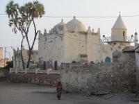 |
| Harbour of
Massawa By Reinhard Dietrich - CC0 |
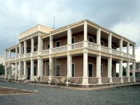
The old Italian city administration
building on Taulud Island at Massawa By David Stanley - CC BY 2.0 |
Historic center
of Massawa By Reinhard Dietrich - CC0 |
You can download for free this Flight Plan but only for your own private use. It is strictly forbidden to share it or publish it in other sites, forums, newsgroups or in any other way . You are encouraged to share and publish links to this page only, but not direct links to the file itself.
(*1) Credits: The descriptive texts are mainly an excerpt of those provided by Wikipedia. Visit Wikipedia to read the full descriptions.
See other MS Flight Simulator flight plans and instructions
Disclaimer: These instructions and flight plan are intended to be used only for MS Flight Simulator and should not be used for real flights.